
1966 Map of Admiral
USGS Topo · Published 1969About this map
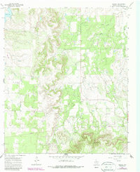
Belle Plain serves as a focal point for Callahan County history on this mid-1960s survey, marked by its Belle Plain Cem and ruins that hint at its 19th-century prominence. A Belle Plain Historical Marker designates the site of this once-thriving frontier town and college site, which sits at the edge of a landscape defined by the drainage of Deep Creek and the West Fork of the Brazos River. To the east, the small settlement of Admiral anchors a rural network of ranch roads and scattered oil wells. The topography is shaped by the prominent Spring Gap and Spring Gap 2, while Baird Lake in the northwest corner provides a key water source for the region. The map captures a transition from traditional ranching and the memories of early Texas settlements to the industrial presence of modern oil extraction and utility pipelines.
Find a feature on this map
14 named features on this map. Tap any name to fly to it.
Don’t see what you’re looking for? This feature index may not catch every label — zoom into the map to look around manually.
Map Details
Editions of this 1966 Admiral Map
2 editions found
Other maps of this area

1931 · Baird
USGS Topo · 1:125,000

1932 · Baird
USGS Topo · 1:125,000

1954 · Abilene
USGS Topo · 1:250,000

1958 · Abilene
USGS Topo · 1:250,000

1966 · Putnam South
USGS Topo · 1:24,000
1966 · Baird
USGS Topo · 1:24,000
1966 · Putnam North
USGS Topo · 1:24,000
1966 · Cub Hollow
USGS Topo · 1:24,000
1966 · Jayell
USGS Topo · 1:24,000
1968 · Rowden
USGS Topo · 1:24,000