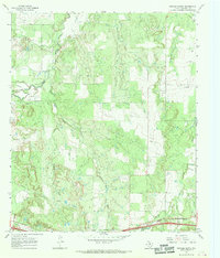
1966 Map of Putnam North
USGS Topo · Published 1969About this map
Deep Creek and its many tributaries carve through the rolling Callahan County landscape, defining the rural character of this mid-1960s survey. The map centers on a landscape dominated by the energy and ranching economy, where numerous Oil Wells, a Drill Hole, and a Gravel Pit are scattered among the drainage basins of Battle Creek and Post Oak Creek. Near the southern edge, the settlement of Putnam serves as a small focal point, while the northern reaches reveal an Old Railroad Grade and a network of buried pipelines. Genealogists will find the Hart Cem located near the junction of Sheep Creek and Oak Creek, providing a specific point of interest for family history research in this part of North Texas.
Find a feature on this map
19 named features on this map. Tap any name to fly to it.
Don’t see what you’re looking for? This feature index may not catch every label — zoom into the map to look around manually.
Map Details
Editions of this 1966 Putnam North Map
This is the sole edition of this map. No revisions or reprints were ever made.
Other maps of this area

1892 · Albany
USGS Topo · 1:125,000

1893 · Albany
USGS Topo · 1:125,000

1931 · Baird
USGS Topo · 1:125,000

1932 · Baird
USGS Topo · 1:125,000

1954 · Abilene
USGS Topo · 1:250,000

1958 · Abilene
USGS Topo · 1:250,000
1965 · Snyder Lake
USGS Topo · 1:24,000

1965 · Indian Knoll
USGS Topo · 1:24,000
1965 · Moran
USGS Topo · 1:24,000

1966 · Scranton
USGS Topo · 1:24,000