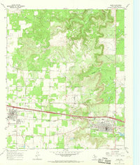
1966 Map of Baird
USGS Topo · Published 1969About this map
Clyde and Baird serve as the primary hubs in this West Texas landscape during the late 1960s, both situated along the vital transport corridor of the Texas and Pacific railroad and the recently constructed Interstate 20. The geography is defined by a series of north-flowing watercourses, including Jenkins Creek, Hubbard Creek, and Keener Creek, which carve through the terrain north of the rail line. Oil production is a visible driver of the local economy, with numerous Oil Wells and an Oil Well marked across the northern sections.
Find a feature on this map
21 named features on this map. Tap any name to fly to it.
Don’t see what you’re looking for? This feature index may not catch every label — zoom into the map to look around manually.
Map Details
Editions of this 1966 Baird Map
2 editions found
Other maps of this area

1890 · Abilene
USGS Topo · 1:125,000

1891 · Anson
USGS Topo · 1:125,000

1892 · Abilene
USGS Topo · 1:125,000

1892 · Albany
USGS Topo · 1:125,000

1893 · Albany
USGS Topo · 1:125,000

1893 · Anson
USGS Topo · 1:125,000

1931 · Baird
USGS Topo · 1:125,000

1932 · Baird
USGS Topo · 1:125,000

1954 · Abilene
USGS Topo · 1:250,000

1957 · Kirby Lake
USGS Topo · 1:62,500