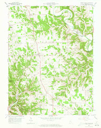
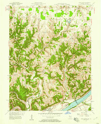
1959 Map of Cross Plains
USGS Topo · Published 1979About this map
Laughery Creek carves a winding path through the borderlands of Ripley, Dearborn, and Ohio counties, defining the complex topography of this southeastern Indiana landscape. The settlement at Cross Plains serves as a central hub, situated where Route 62 and Route 129 intersect. The map reveals a dense network of 19th-century rural infrastructure, including numerous family and church cemeteries like Beebe Cem and Nickolson Cem that point to generations of localized settlement. Ridges such as Poplar Ridge and Trot Ridge separate the various drainages, where small communities like Friendship and Olean are centered around local institutions. Cultural landmarks are frequent, ranging from the Township Sch near Avonburg to several houses of worship, including St Pauls Ch and the Bear Creek Ch. This 1959 survey records the region just before modern agricultural and residential shifts altered the historic patterns of these upland township communities.
Find a feature on this map
65 named features on this map. Tap any name to fly to it.
Don’t see what you’re looking for? This feature index may not catch every label — zoom into the map to look around manually.
Map Details
Editions of this 1959 Cross Plains Map
4 editions found
Other maps of this area

1943 · Vevay North
USGS Topo · 1:24,000

1946 · Versailles
USGS Topo · 1:24,000

1946 · Milan
USGS Topo · 1:24,000

1953 · Cincinnati
USGS Topo · 1:250,000

1956 · Bennington
USGS Topo · 1:24,000

1956 · Canaan
USGS Topo · 1:24,000

1956 · Louisville
USGS Topo · 1:250,000

1957 · Cincinnati
USGS Topo · 1:250,000
1957 · Vevay North
USGS Topo · 1:24,000

1958 · Dillsboro
USGS Topo · 1:24,000