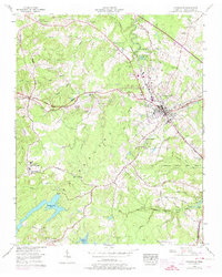
1956 Map of Crossville
USGS Topo · Published 1974About this map
Crossville serves as the central hub of this mid-century Cumberland County survey, situated on the Cumberland Plateau along the path of the Tennessee Central Railroad. The landscape is defined by the Tennessee Valley Divide, which separates the drainages of the Obed River and Byrd Creek. To the south, Cumberland Mountain State Park encompasses Byrd Lake, illustrating the development of recreational land in the post-war era. The map highlights numerous small rural settlements such as Lantana, Pomona, and Howard Springs, each often centered around community landmarks like Mountain View Ch or Oak Hill Ch. This 1950s data, later updated in the 1960s, documents the expansion of Crossville and the integration of the Crossville Municipal Airport and Cumberland Medical Center into the regional infrastructure.
Find a feature on this map
54 named features on this map. Tap any name to fly to it.
Don’t see what you’re looking for? This feature index may not catch every label — zoom into the map to look around manually.
Map Details
Editions of this 1956 Crossville Map
3 editions found
Other maps of this area

1887 · Kingston
USGS Topo · 1:125,000

1891 · Kingston
USGS Topo · 1:125,000

1892 · Pikeville
USGS Topo · 1:125,000

1893 · Kingston
USGS Topo · 1:125,000

1895 · Wartburg
USGS Topo · 1:125,000

1895 · Pikeville
USGS Topo · 1:125,000

1896 · Wartburg
USGS Topo · 1:125,000

1897 · Standingstone
USGS Topo · 1:125,000

1898 · Standingstone
USGS Topo · 1:125,000

1912 · Crossville
USGS Topo · 1:62,500