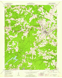
1956 Map of Crossville
USGS Topo · Published 1958About this map
Crossville serves as the focal point of this Cumberland Plateau landscape, positioned along the Tennessee Central railroad and U. S. Highway 127. The area is defined by its transition from a bustling mountain town to the outlying rural settlements of Baker Crossroads, Howard Springs, and Lantana. Genealogists will find a dense concentration of family burial grounds, including Baisley Cem, Graham Cem, and Leggett Cem, which anchor the early community history of this high plateau region.
Find a feature on this map
60 named features on this map. Tap any name to fly to it.
Don’t see what you’re looking for? This feature index may not catch every label — zoom into the map to look around manually.
Map Details
Editions of this 1956 Crossville Map
3 editions found
Other maps of this area

1887 · Kingston
USGS Topo · 1:125,000

1891 · Kingston
USGS Topo · 1:125,000

1892 · Pikeville
USGS Topo · 1:125,000

1893 · Kingston
USGS Topo · 1:125,000

1895 · Wartburg
USGS Topo · 1:125,000

1895 · Pikeville
USGS Topo · 1:125,000

1896 · Wartburg
USGS Topo · 1:125,000

1897 · Standingstone
USGS Topo · 1:125,000

1898 · Standingstone
USGS Topo · 1:125,000

1912 · Crossville
USGS Topo · 1:62,500