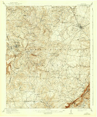
1912 Map of Crossville
USGS Topo · Published 1941About this map
Crossville serves as the eastern hub of this 1910 survey, situated at the junction of the Tennessee Central RR on the Cumberland Plateau. The landscape is a network of small upland communities and rural landmarks, including Pleasant Hill, Pomona, and Baker Crossroads. Genealogists will find a wealth of local points of interest, such as Smith Chapel, Zion Church, and Hale Chapel, alongside several remote schoolhouses like the Burgess School and Flynn School.
Find a feature on this map
85 named features on this map. Tap any name to fly to it.
Don’t see what you’re looking for? This feature index may not catch every label — zoom into the map to look around manually.
Map Details
Editions of this 1912 Crossville Map
2 editions found

Other maps of this area

1887 · Kingston
USGS Topo · 1:125,000

1891 · Kingston
USGS Topo · 1:125,000

1892 · Pikeville
USGS Topo · 1:125,000

1893 · Kingston
USGS Topo · 1:125,000

1895 · Wartburg
USGS Topo · 1:125,000

1895 · Pikeville
USGS Topo · 1:125,000

1896 · Wartburg
USGS Topo · 1:125,000

1897 · Standingstone
USGS Topo · 1:125,000

1898 · Standingstone
USGS Topo · 1:125,000

1909 · Sequatchie Valley
USGS Topo · 1:62,500