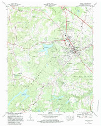
1982 Map of Crossville
USGS Topo · Published 1983About this map
Crossville stands as the hub of the high Cumberland Plateau in the early 1980s, where the city's growth is clearly mapped alongside the enduring rural character of its surrounding crossroads. The landscape is defined by the Tennessee Divide and a complex network of man-made lakes, including the large Meadow Park Lake and the recreational developments at Lake Tansi Village. The transition from the town's industrial and civic core—marked by the National Guard Armory and Cumberland Medical Center—to the outlying residential enclaves like Volunteer Heights and Camelot reflects the era's suburban expansion.
Find a feature on this map
87 named features on this map. Tap any name to fly to it.
Don’t see what you’re looking for? This feature index may not catch every label — zoom into the map to look around manually.
Map Details
Editions of this 1982 Crossville Map
2 editions found
Other maps of this area

1887 · Kingston
USGS Topo · 1:125,000

1891 · Kingston
USGS Topo · 1:125,000

1892 · Pikeville
USGS Topo · 1:125,000

1893 · Kingston
USGS Topo · 1:125,000

1895 · Wartburg
USGS Topo · 1:125,000

1895 · Pikeville
USGS Topo · 1:125,000

1896 · Wartburg
USGS Topo · 1:125,000

1897 · Standingstone
USGS Topo · 1:125,000

1898 · Standingstone
USGS Topo · 1:125,000

1912 · Crossville
USGS Topo · 1:62,500