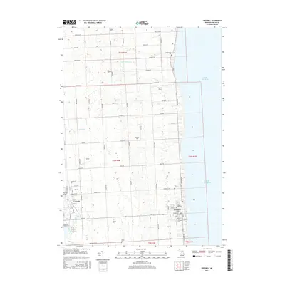
2017 Map of Croswell
USGS Topo · Published 2017About this map
Croswell and the western shores of Lake Huron define this Sanilac County landscape as it appeared in the late 2010s. The region is marked by a precise grid of rural roads and the meandering courses of the Black River and Mill Creek. Local genealogy and land history are preserved through an exceptional density of family and community burial sites, including the Old Lexington Cemetery and Wixson Cemetery. The area's small-town infrastructure is visible in the street plans of Croswell and the adjacent shoreline community, connected by routes like Peck Road and Lakeshore Road. Unique local landmarks like Flugplatz Airport and Harrington Bridge anchor the terrain between the agricultural fields and the vast expanse of the Great Lake.
Find a feature on this map
52 named features on this map. Tap any name to fly to it.
Don’t see what you’re looking for? This feature index may not catch every label — zoom into the map to look around manually.
Map Details
Editions of this 2017 Croswell Map
This is the sole edition of this map. No revisions or reprints were ever made.
Other maps of this area

1954 · Flint
USGS Topo · 1:250,000

1958 · Flint
USGS Topo · 1:250,000

1961 · Roseburg
USGS Topo · 1:24,000
1961 · Jeddo
USGS Topo · 1:24,000

1963 · Croswell
USGS Topo · 1:24,000

1963 · Port Sanilac
USGS Topo · 1:24,000

1963 · Applegate
USGS Topo · 1:24,000
1963 · Carsonville
USGS Topo · 1:24,000

1984 · Croswell
USGS Topo · 1:100,000

2011 · Jeddo OE E
USGS Topo · 1:24,000