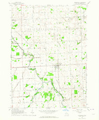
1963 Map of Carsonville
USGS Topo · Published 1964About this map
Carsonville sits at the intersection of a sprawling network of agricultural drains and the Chesapeake and Ohio railroad during the early 1960s. The landscape of Sanilac County is defined by its complex water management system, featuring numerous engineered waterways like the Berry Drain, Shrapnell Drain, and McDonald Drain that feed into the prominent Black River. These drains suggest a highly developed rural economy focused on land reclamation for farming. Scattered throughout the townships of Bridgehampton and Washington are the vestiges of mid-century community life, including several rural schoolhouses such as Black River Sch and Butler Sch. Along the river's edge, recreational and industrial markers appear side-by-side, from the Black River Roadside Park and a Drive-in Theater to a local Salt Well, illustrating the diverse uses of the river corridor during this era.
Find a feature on this map
52 named features on this map. Tap any name to fly to it.
Don’t see what you’re looking for? This feature index may not catch every label — zoom into the map to look around manually.
Map Details
Editions of this 1963 Carsonville Map
2 editions found
Other maps of this area

1954 · Flint
USGS Topo · 1:250,000

1958 · Flint
USGS Topo · 1:250,000

1963 · Sandusky
USGS Topo · 1:24,000

1963 · Peck
USGS Topo · 1:24,000

1963 · Croswell
USGS Topo · 1:24,000

1963 · Port Sanilac
USGS Topo · 1:24,000

1963 · Palms
USGS Topo · 1:24,000

1963 · Applegate
USGS Topo · 1:24,000

1963 · Deckerville
USGS Topo · 1:24,000

1963 · Richmondville
USGS Topo · 1:24,000
Featured Places
- Carsonville, MI
- Forester Township, MI
- Bridgehampton Township, MI
- Washington Township, MI
- Sanilac Township, MI