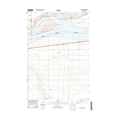
2013 Map of Crow Butte
USGS Topo · Published 2013About this map
The Columbia River serves as the dominant geographical and political boundary here, separating Washington and Oregon while defining the local economy of the Mid-Columbia region. In the northern section, the high ground of Canoe Ridge and Quarry Butte overlooks the river, while the settlement of Whitcomb sits near the tracks of a major rail line and Whitcomb Island. This landscape is marked by the distinct topographic features of the basalt plateaus, including the prominent Crow Butte rising from the riverbed and the deep scars of Artesian Coulee and Dead Canyon. On the southern Oregon shore, the terrain transitions to a managed agricultural and transportation corridor. The W Extension Irrigation Canal winds through the landscape south of the Boardman Airport, illustrating the extensive water management systems required for farming in this arid environment. The road network, including Wa-14 and Tower RD, connects the scattered farmsteads and rural infrastructure that define this borderland region.
Find a feature on this map
34 named features on this map. Tap any name to fly to it.
Don’t see what you’re looking for? This feature index may not catch every label — zoom into the map to look around manually.
Map Details
Editions of this 2013 Crow Butte Map
This is the sole edition of this map. No revisions or reprints were ever made.
Other maps of this area

1906 · Blalock Island
USGS Topo · 1:125,000

1908 · Blalock Island
USGS Topo · 1:125,000

1953 · Pendleton
USGS Topo · 1:250,000

1956 · Pendleton
USGS Topo · 1:250,000
1962 · Phinny Hill
USGS Topo · 1:24,000

1962 · Canoe Ridge
USGS Topo · 1:24,000

1962 · Alderdale
USGS Topo · 1:24,000

1962 · Blalock Island
USGS Topo · 1:24,000

1962 · Boardman
USGS Topo · 1:24,000

1962 · Crow Butte
USGS Topo · 1:24,000