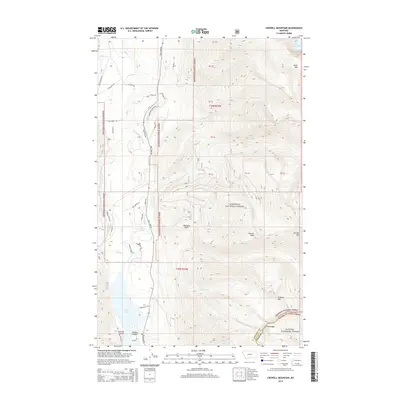
2014 Map of Crowell Mountain
USGS Topo · Published 2014About this map
Bull Lake dominates the southwestern corner of this mountain landscape, its eastern shore traced by Bull Lake Rd and dotted with small named features like Callows Island and Emma Gulch. The terrain rises sharply to the east into the protected lands of the Kootenai National Forest and Kanisku National Forest, where high summits such as Crowell Mtn, Doonan Peak, and Gordon Mtn define the Cabinet Mountains wilderness. The network of drainage including Crowell Cr and Hidden Cr flows westward from these peaks toward the Lake Cr valley. This 2014 survey captures a moment when the wilderness boundary meets the developing shoreline of Bull Lake, where numerous residential access ways like Hidden Estates Rd and Diamond T Trl have been established amidst the older forest service routes.
Find a feature on this map
56 named features on this map. Tap any name to fly to it.
Don’t see what you’re looking for? This feature index may not catch every label — zoom into the map to look around manually.
Map Details
Editions of this 2014 Crowell Mountain Map
This is the sole edition of this map. No revisions or reprints were ever made.
Other maps of this area

1920 · Libby
USGS Topo · 1:125,000

1930 · Libby
USGS Topo · 1:125,000

1932 · Libby
USGS Topo · 1:125,000

1957 · Kalispell
USGS Topo · 1:250,000

1960 · Kalispell
USGS Topo · 1:250,000

1961 · Kalispell
USGS Topo · 1:250,000

1963 · Scenery Mountain
USGS Topo · 1:24,000
1963 · Spar Lake
USGS Topo · 1:24,000
1963 · Troy
USGS Topo · 1:24,000

1963 · Treasure Mountain
USGS Topo · 1:24,000