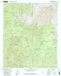
1969 Map of Crown King
USGS Topo · Published 1988About this map
The settlement of Crown King and its surrounding mining districts define this 1969 survey of the Bradshaw Mountains. This high-altitude landscape is densely concentrated with the remains of a late 19th-century gold and silver boom, featuring a complex network of pack trails and jeep roads connecting historic sites like the Gladiator Mine, Oro Belle Mine, and Standard Mine. The presence of the Bradshaw City (Site) and its corresponding Bradshaw City Cem provides a clear view of the area's transition from a bustling mining hub to a more seasonal and recreational character within the Prescott National Forest.
Find a feature on this map
96 named features on this map. Tap any name to fly to it.
Don’t see what you’re looking for? This feature index may not catch every label — zoom into the map to look around manually.
Map Details
Editions of this 1969 Crown King Map
4 editions found
Other maps of this area

1887 · Prescott
USGS Topo · 1:250,000

1892 · Prescott
USGS Topo · 1:250,000

1903 · Bradshaw Mountains
USGS Topo · 1:125,000

1947 · Crown King
USGS Topo · 1:62,500

1947 · Bumblebee
USGS Topo · 1:62,500

1947 · Mayer
USGS Topo · 1:62,500

1947 · Mt. Union
USGS Topo · 1:62,500

1948 · Bumblebee
USGS Topo · 1:63,360

1948 · Crown King
USGS Topo · 1:63,360

1948 · Mt. Union
USGS Topo · 1:63,360