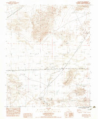
1983 Map of Crucero Hill
USGS Topo · Published 1983About this map
Mojave River Sink dominates the central basin of this arid landscape, where the seasonal river flow terminates in the vast desert floor. The settlement of Crucero serves as a critical junction point, situated at the intersection of a live railroad line and an Old RR Grade that traces the historic transportation routes of the eastern Mojave. This area reflects the mid-century transition of desert travel, evidenced by the infrastructure of a gas line and several protective levee structures built to manage the unpredictable desert hydrology. To the north and south, the topography rises sharply into the Soda Mountains and the Mesquite Hills. Remote outposts like Rasor Ranch and natural water sources such as Mesquite Spring provide rare points of habitation and life in an environment defined by the dry bed of the Crucero Wash.
Find a feature on this map
14 named features on this map. Tap any name to fly to it.
Don’t see what you’re looking for? This feature index may not catch every label — zoom into the map to look around manually.
Map Details
Editions of this 1983 Crucero Hill Map
3 editions found
Other maps of this area

1933 · Avawatz Mountains
USGS Topo · 1:250,000

1947 · Trona
USGS Topo · 1:250,000

1948 · Trona
USGS Topo · 1:250,000

1948 · Cave Mountain
USGS Topo · 1:62,500

1951 · Cave Mountain
USGS Topo · 1:62,500

1953 · San Bernardino
USGS Topo · 1:250,000

1953 · Trona
USGS Topo · 1:250,000

1955 · Cady Mountains
USGS Topo · 1:62,500

1955 · Broadwell Lake
USGS Topo · 1:62,500

1956 · San Bernardino
USGS Topo · 1:250,000