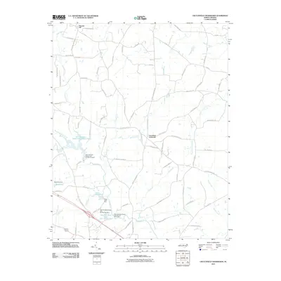
2010 Map of Crutchfield Crossroads
USGS Topo · Published 2010About this map
The Rocky River and its numerous tributaries define the rural landscape of central North Carolina as it appeared in the early 21st century. This area is characterized by a network of critical reservoirs, most notably Siler City Water Supply Lake Number One and Siler City Water Supply Lake Number Two, which are essential to the regional infrastructure. Small rural communities like Crutchfield Crossroads and Pleasant Hill anchor a dense grid of country lanes, many bearing family names that indicate long-standing local ties.
Find a feature on this map
79 named features on this map. Tap any name to fly to it.
Don’t see what you’re looking for? This feature index may not catch every label — zoom into the map to look around manually.
Map Details
Editions of this 2010 Crutchfield Crossroads Map
This is the sole edition of this map. No revisions or reprints were ever made.
Other maps of this area

1953 · Raleigh
USGS Topo · 1:250,000

1954 · Raleigh
USGS Topo · 1:250,000

1968 · Coleridge
USGS Topo · 1:24,000

1969 · Siler City
USGS Topo · 1:24,000

1970 · Kimesville
USGS Topo · 1:24,000

1970 · Siler City NE
USGS Topo · 1:24,000

1974 · Silk Hope
USGS Topo · 1:24,000

1974 · Crutchfield Crossroads
USGS Topo · 1:24,000
1974 · Liberty
USGS Topo · 1:24,000
1977 · Saxapahaw
USGS Topo · 1:24,000