
1970 Map of Siler City NE
USGS Topo · Published 1973About this map
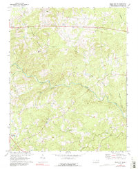
The Hickory Mountain ridge dominates the northern landscape of this Chatham County region, where the Rocky River winds through dense woodlands and small clearings. In the early 1970s, this area remained largely rural, defined by a network of country churches that served as community hubs, including Evans Chapel, Hives Chapel, and Union Grove Ch. The settlement of Landrum and the community at Carolina Hill are linked by winding secondary roads, while the more modern corridor of Route 64 skirts the northern edge near Roadside Park. Numerous watercourses like Tick Creek and Harlands Creek feed into the river system, reflecting a landscape shaped by its drainage patterns. For local historians, the distribution of these small churches and unnamed cemeteries provides evidence of long-standing family settlements within the river valley.
Find a feature on this map
32 named features on this map. Tap any name to fly to it.
Don’t see what you’re looking for? This feature index may not catch every label — zoom into the map to look around manually.
Map Details
Editions of this 1970 Siler City NE Map
2 editions found
Other maps of this area

1953 · Raleigh
USGS Topo · 1:250,000

1954 · Raleigh
USGS Topo · 1:250,000

1968 · Bynum
USGS Topo · 1:24,000

1969 · Siler City
USGS Topo · 1:24,000

1970 · Goldston
USGS Topo · 1:24,000

1970 · Pittsboro
USGS Topo · 1:24,000

1970 · Colon
USGS Topo · 1:24,000

1970 · Bear Creek
USGS Topo · 1:24,000

1974 · Silk Hope
USGS Topo · 1:24,000

1974 · Crutchfield Crossroads
USGS Topo · 1:24,000