
1974 Map of Crutchfield Crossroads
USGS Topo · Published 1976About this map
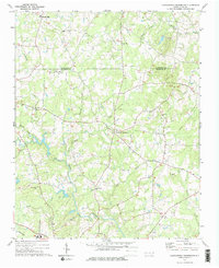
Crutchfield Crossroads serves as a central hub in this mid-1970s survey of the rural borderlands where the Alamance Co Chatham Co line divides the landscape. The region is defined by its numerous community landmarks, including a high concentration of country churches such as Bethlehem Ch, Flint Ridge Ch, and Rocky River Ch. The topography is shaped by the Rocky River and its many tributaries, including Lick Creek, Mud Creek, and Greenbrier Creek. In the southwest corner, the Southern railroad line cuts through the terrain, while infrastructure like a Filtration Plant and a Pumping Sta near a Claypit in the northeast indicate the area's utility and industrial footprints. Small settlements like Pleasant Hill and Plainfield are surrounded by dense woodlands and winding creek beds, offering a detailed look at the rural settlement patterns before significant modern expansion.
Find a feature on this map
27 named features on this map. Tap any name to fly to it.
Don’t see what you’re looking for? This feature index may not catch every label — zoom into the map to look around manually.
Map Details
Editions of this 1974 Crutchfield Crossroads Map
2 editions found
Other maps of this area

1953 · Raleigh
USGS Topo · 1:250,000

1954 · Raleigh
USGS Topo · 1:250,000

1968 · Coleridge
USGS Topo · 1:24,000

1969 · Siler City
USGS Topo · 1:24,000

1970 · Kimesville
USGS Topo · 1:24,000

1970 · Siler City NE
USGS Topo · 1:24,000

1974 · Silk Hope
USGS Topo · 1:24,000
1974 · Liberty
USGS Topo · 1:24,000
1977 · Saxapahaw
USGS Topo · 1:24,000
1978 · Snow Camp
USGS Topo · 1:24,000