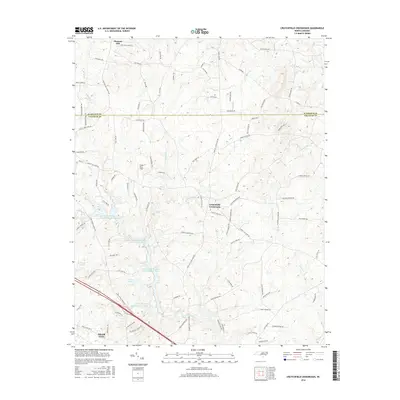
2016 Map of Crutchfield Crossroads
USGS Topo · Published 2016About this map
The Rocky River and its numerous tributaries, including Mud Lick Cr and Nick Cr, define the drainage and topography along the border of Alamance and Chatham Counties. In the southern portion of the map, the industrial and municipal footprint of Siler City is evident through a series of significant reservoirs: Siler City Water Supply Lake Number One, Siler City Water Supply Lake Number Two, and Siler City Water Supply Lake Number Three. These water bodies, along with private features like Clapp Pond, underscore the transition from the town's edge to the rural landscape surrounding Crutchfield Crossroads. The map reveals a dense network of family-named roads and rural trails, such as Fogleman Trl and Sam Dark Rd, which provide important clues for genealogists tracking local landholdings near Pleasant Hill.
Find a feature on this map
101 named features on this map. Tap any name to fly to it.
Don’t see what you’re looking for? This feature index may not catch every label — zoom into the map to look around manually.
Map Details
Editions of this 2016 Crutchfield Crossroads Map
This is the sole edition of this map. No revisions or reprints were ever made.
Other maps of this area

1953 · Raleigh
USGS Topo · 1:250,000

1954 · Raleigh
USGS Topo · 1:250,000

1968 · Coleridge
USGS Topo · 1:24,000

1969 · Siler City
USGS Topo · 1:24,000

1970 · Kimesville
USGS Topo · 1:24,000

1970 · Siler City NE
USGS Topo · 1:24,000

1974 · Silk Hope
USGS Topo · 1:24,000

1974 · Crutchfield Crossroads
USGS Topo · 1:24,000
1974 · Liberty
USGS Topo · 1:24,000
1977 · Saxapahaw
USGS Topo · 1:24,000