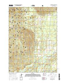
2017 Map of Cryder Butte
USGS Topo · Published 2017About this map
Deschutes National Forest dominates this Central Oregon landscape, where the volcanic topography of the High Desert meets a complex network of forest roads and waterways. Significant volcanic landmarks like Cryder Butte, Eagle Rock, and Ringo Butte rise above the terrain, providing distinct navigational points within the dense timberlands. The southern portion of the sheet is defined by the winding course of the Little Deschutes River and Crescent Cr, which are joined by man-made infrastructure such as the Mayfield Ditch and the crossing at Kemp Bridge. This area illustrates the management of water resources and timber access in the early 21st century, with the Gilchrist Express and numerous National Forest Development Roads like Nat For Dev Rd 6220 and Nat For Dev Rd 300 creating a grid for resource extraction and fire management across the Deschutes and Klamath county line.
Find a feature on this map
25 named features on this map. Tap any name to fly to it.
Don’t see what you’re looking for? This feature index may not catch every label — zoom into the map to look around manually.
Map Details
Editions of this 2017 Cryder Butte Map
This is the sole edition of this map. No revisions or reprints were ever made.
Other maps of this area

1930 · Maiden Peak
USGS Topo · 1:125,000

1934 · Maiden Peak
USGS Topo · 1:125,000

1935 · Chemult
USGS Topo · 1:96,000

1941 · Chemult
USGS Topo · 1:125,000

1955 · Crescent
USGS Topo · 1:250,000

1957 · Crescent
USGS Topo · 1:250,000

1958 · Crescent
USGS Topo · 1:250,000

1963 · Hamner Butte
USGS Topo · 1:24,000

1963 · La Pine
USGS Topo · 1:24,000

1963 · Masten Butte
USGS Topo · 1:24,000