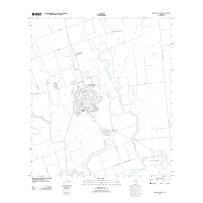
2013 Map of Crystal City
USGS Topo · Published 2013About this map
The Crystal City street grid dominates this south Texas landscape, centered on a dense network of local roads and state highways. Established along the Nueces River valley, the city's development is closely tied to its agricultural and industrial surroundings, including the Elaine Oil Field to the southeast. Water management is a defining characteristic of the area, as seen in the complex system of natural and human-altered waterways like Alligator Slough, Espantosa Slough, and the Boynton Reservoir. To the south of the main settlement, the smaller community of River Spur is situated near the riverbanks. Local heritage is preserved at sites like Edgewood Cem and Juarez Cem, while the Crystal City Municipal Airport serves as a modern transportation link for this Zavala County hub.
Find a feature on this map
66 named features on this map. Tap any name to fly to it.
Don’t see what you’re looking for? This feature index may not catch every label — zoom into the map to look around manually.
Map Details
Editions of this 2013 Crystal City Map
This is the sole edition of this map. No revisions or reprints were ever made.
Other maps of this area

1939 · Carrizo Springs
USGS Topo · 1:62,500

1939 · Big Wells
USGS Topo · 1:62,500

1939 · La Pryor
USGS Topo · 1:62,500

1953 · Crystal City
USGS Topo · 1:250,000

1955 · Crystal City
USGS Topo · 1:250,000

1957 · Batesville
USGS Topo · 1:62,500

1961 · Crystal City
USGS Topo · 1:250,000

1968 · Crystal City
USGS Topo · 1:250,000
1972 · Beef Hollow Creek
USGS Topo · 1:24,000
1972 · Carrizo Springs NW
USGS Topo · 1:24,000
Featured Places
- Crystal City, TX
- Popeye Lake Colonia, TX
- Amaya Colonia, TX
- Loma Grande Colonia, TX
- Triangula Colonia, TX