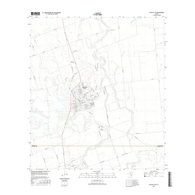
2016 Map of Crystal City
USGS Topo · Published 2016About this map
Crystal City serves as the hub of this South Texas landscape, defined by a dense grid of streets and key community landmarks like Edgewood Cem and Juarez Cem. The surrounding terrain is a complex hydrologic network where the Nueces River winds southward, flanked by numerous oxbows and seasonal water bodies including Duck Lake and the expansive Espantosa Lake to the south. Just north of the main settlement, the smaller community of Amaya sits along the Old Uvalde Hwy.
Find a feature on this map
94 named features on this map. Tap any name to fly to it.
Don’t see what you’re looking for? This feature index may not catch every label — zoom into the map to look around manually.
Map Details
Editions of this 2016 Crystal City Map
This is the sole edition of this map. No revisions or reprints were ever made.
Other maps of this area

1939 · Carrizo Springs
USGS Topo · 1:62,500

1939 · Big Wells
USGS Topo · 1:62,500

1939 · La Pryor
USGS Topo · 1:62,500

1953 · Crystal City
USGS Topo · 1:250,000

1955 · Crystal City
USGS Topo · 1:250,000

1957 · Batesville
USGS Topo · 1:62,500

1961 · Crystal City
USGS Topo · 1:250,000

1968 · Crystal City
USGS Topo · 1:250,000
1972 · Beef Hollow Creek
USGS Topo · 1:24,000
1972 · Carrizo Springs NW
USGS Topo · 1:24,000
Featured Places
- Crystal City, TX
- Popeye Lake Colonia, TX
- Amaya Colonia, TX
- Loma Grande Colonia, TX
- Triangula Colonia, TX