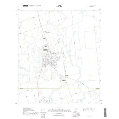
2019 Map of Crystal City
USGS Topo · Published 2019About this map
Crystal City serves as the central hub of this South Texas landscape, where the street grid of the town center transitions into outlying residential developments like Bushy Creek-Colonia and Camposanto-Elcometa Colonia. The topography is defined by the winding course of the Nueces River and its associated drainage networks, including Alligator Slough and Espantosa Slough. These water features create a complex riparian environment that historically dictated the placement of early settlements and agricultural boundaries.
Find a feature on this map
101 named features on this map. Tap any name to fly to it.
Don’t see what you’re looking for? This feature index may not catch every label — zoom into the map to look around manually.
Map Details
Editions of this 2019 Crystal City Map
This is the sole edition of this map. No revisions or reprints were ever made.
Other maps of this area

1939 · Carrizo Springs
USGS Topo · 1:62,500

1939 · Big Wells
USGS Topo · 1:62,500

1939 · La Pryor
USGS Topo · 1:62,500

1953 · Crystal City
USGS Topo · 1:250,000

1955 · Crystal City
USGS Topo · 1:250,000

1957 · Batesville
USGS Topo · 1:62,500

1961 · Crystal City
USGS Topo · 1:250,000

1968 · Crystal City
USGS Topo · 1:250,000
1972 · Beef Hollow Creek
USGS Topo · 1:24,000
1972 · Carrizo Springs NW
USGS Topo · 1:24,000
Featured Places
- Crystal City, TX
- Popeye Lake Colonia, TX
- Amaya Colonia, TX
- Loma Grande Colonia, TX
- Triangula Colonia, TX