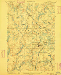
1899 Map of Crystal Falls
USGS Topo · Published 1910About this map
Iron mining and complex rail systems define the landscape of the Upper Peninsula at the turn of the century, centered on the growing industrial hub of Crystal Falls. This 1890s survey, conducted by Muldrow and Van Hise, documents the critical early infrastructure of Iron County. The map details the expansion of the Chicago and Northwestern and the Chicago Milwaukee and St. Paul railroads, including specialized spurs like the Armenia Branch and the C. and N. W. R. R. Dunn Mine Branch that serviced heavy industry. Key extraction points such as the Shafer Mine and Mastodon Mine are situated near the banks of the Paint River, illustrating how topography and natural resources dictated the early settlement patterns of Hematite and Mastodon townships. Numerous water bodies like the Fortune Lakes and Chicagon Lake break up the industrial activity, showing the original character of this mining district.
Find a feature on this map
44 named features on this map. Tap any name to fly to it.
Don’t see what you’re looking for? This feature index may not catch every label — zoom into the map to look around manually.
Map Details
Editions of this 1899 Crystal Falls Map
2 editions found
Other maps of this area

1895 · Ned Lake
USGS Topo · 1:62,500

1895 · Perch Lake
USGS Topo · 1:62,500

1898 · Iron River
USGS Topo · 1:62,500

1899 · Sagola
USGS Topo · 1:62,500

1899 · Witbeck
USGS Topo · 1:62,500

1899 · Crystal Falls
USGS Topo · 1:62,500

1939 · Long Lake
USGS Topo · 1:48,000

1939 · Iron Mountain
USGS Topo · 1:48,000

1941 · Florence
USGS Topo · 1:48,000

1941 · Iron Mountain
USGS Topo · 1:48,000