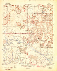
1945 Map of Crystal Lake
USGS Topo · Published 1945About this map
Crystal Lake and its surrounding sinkhole ponds define this landscape along the Washington Co Bay Co line at the end of the Second World War. The area is characterized by an extensive network of named water bodies, ranging from the large Blue Pond in the west to smaller, curiously named features like Rattlesnake Lake, Shirt Tail Lake, and Court Martial Lake. These isolated basins reflect the unique karst topography of the Florida Panhandle, where drainage is primarily subterranean rather than through defined river systems.
Find a feature on this map
39 named features on this map. Tap any name to fly to it.
Don’t see what you’re looking for? This feature index may not catch every label — zoom into the map to look around manually.
Map Details
Editions of this 1945 Crystal Lake Map
3 editions found

Other maps of this area

1943 · West Bay
USGS Topo · 1:24,000

1943 · Southport
USGS Topo · 1:24,000

1944 · Southport
USGS Topo · 1:24,000

1944 · West Bay
USGS Topo · 1:31,680

1944 · Crystal Lake
USGS Topo · 1:24,000

1944 · Bayhead
USGS Topo · 1:24,000

1944 · Bennett
USGS Topo · 1:24,000

1945 · Bennett
USGS Topo · 1:31,680

1945 · Red Head
USGS Topo · 1:31,680

1945 · Bayhead
USGS Topo · 1:31,680