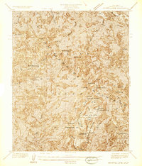
1936 Map of Crystal Lake
USGS Topo · Published 1936About this map
The high peaks of the San Gabriel Mountains dominate this mid-1930s survey, revealing a landscape defined by seasonal recreation and forestry infrastructure before the mid-century expansion of Southern California. Centered on Crystal Lake, the map documents a cluster of developed sites including Wawona Lodge, the YMCA Hut, and a store, reflecting the area's role as a mountain retreat for Los Angeles residents. The presence of the Crystal Lake Guard Station and several designated flats, such as West Pine Flats and East Pine Flats, indicates the active management of the San Gabriel National Forest during this period.
Find a feature on this map
34 named features on this map. Tap any name to fly to it.
Don’t see what you’re looking for? This feature index may not catch every label — zoom into the map to look around manually.
Map Details
Editions of this 1936 Crystal Lake Map
This is the sole edition of this map. No revisions or reprints were ever made.
Other maps of this area

1901 · Southern California Sheet No. 1
USGS Topo · 1:250,000

1903 · Rock Creek
USGS Topo · 1:62,500

1904 · Southern California Sheet No. 1
USGS Topo · 1:250,000

1934 · Mescal Creek
USGS Topo · 1:24,000
1934 · Cima Mesa
USGS Topo · 1:24,000
1934 · Valyermo
USGS Topo · 1:24,000
1934 · Camp Bonita
USGS Topo · 1:24,000
1934 · Camp Rincon
USGS Topo · 1:24,000
1934 · Chileno Canyon
USGS Topo · 1:24,000
1936 · Mt. Baden-Powell
USGS Topo · 1:24,000