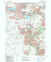
1992 Map of Crystal Lake
USGS Topo · Published 1992About this map
Crystal Lake and the Fox River valley anchor this suburban corridor during a period of significant growth in McHenry and Kane Counties. The map reveals a landscape defined by its glacial lakes, including Silver Lake and Lake Killarney, and the intricate expansion of lakeside communities like Lakewood, Crystal Vista, and North Shore. The presence of numerous Gravel Pits and quarries along the river indicates the region's active industrial underpinnings, while the Chicago and North Western railroad provides the vital commuter link to the broader metropolitan area. Genealogists can locate family sites at Union Cem or Buena Vista Cem, while local historians can trace the development of community infrastructure from the Lake in the Hills Airport to regional hubs like Algonquin and Carpentersville. The survey also highlights substantial conservation efforts at Buffalo Park Forest Preserve and Lippold Park.
Find a feature on this map
104 named features on this map. Tap any name to fly to it.
Don’t see what you’re looking for? This feature index may not catch every label — zoom into the map to look around manually.
Map Details
Editions of this 1992 Crystal Lake Map
This is the sole edition of this map. No revisions or reprints were ever made.
Other maps of this area

1920 · Grays Lake
USGS Topo · 1:62,500

1923 · Grays Lake
USGS Topo · 1:62,500

1923 · Barrington
USGS Topo · 1:62,500

1925 · Elgin
USGS Topo · 1:62,500

1926 · Mc Henry
USGS Topo · 1:62,500

1935 · Barrington
USGS Topo · 1:62,500

1940 · Elgin
USGS Topo · 1:62,500

1944 · McHenry
USGS Topo · 1:62,500

1954 · Rockford
USGS Topo · 1:250,000

1955 · Rockford
USGS Topo · 1:250,000