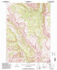
1996 Map of Crystal Peak
USGS Topo · Published 1998About this map
The Gros Ventre Wilderness defines this high-altitude landscape within the Teton National Forest, where steep drainages and jagged summits dominate the terrain. A complex network of watercourses, including West Fork Crystal Creek and Granite Creek, carves through the mountains, illustrating the hydrologic patterns of the Teton region in the late 20th century. High-country landmarks such as Packsaddle Pass and The Meadows provide specific points of reference for navigating the vertical relief between Pyramid Peak and Antoinette Peak. The map captures a wilderness area maintained for its primitive character, showing no developed roads or permanent settlements. Instead, it focuses on the natural geographic features like Box Lake and the prominent summit of Crystal Peak on the eastern edge of the survey, serving as a record of the backcountry as it existed during the 1996 field check.
Find a feature on this map
17 named features on this map. Tap any name to fly to it.
Don’t see what you’re looking for? This feature index may not catch every label — zoom into the map to look around manually.
Map Details
Editions of this 1996 Crystal Peak Map
This is the sole edition of this map. No revisions or reprints were ever made.
Other maps of this area

1899 · Grand Teton
USGS Topo · 1:125,000

1901 · Grand Teton
USGS Topo · 1:125,000

1902 · Mt Leidy
USGS Topo · 1:125,000

1907 · Gros Ventre
USGS Topo · 1:125,000

1910 · Gros Ventre
USGS Topo · 1:125,000

1931 · Jackson
USGS Topo · 1:125,000

1935 · Jackson
USGS Topo · 1:125,000

1955 · Driggs
USGS Topo · 1:250,000

1958 · Driggs
USGS Topo · 1:250,000

1962 · Driggs
USGS Topo · 1:250,000