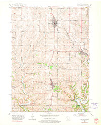
1952 Map of Cuba City
USGS Topo · Published 1981About this map
Mining operations and agricultural centers define this corner of Southwest Wisconsin and Northern Illinois in the early 1950s. The landscape is marked by the lead and zinc mining legacy of the Upper Mississippi Valley, visible through numerous inactive mines, tailings, and the Burkett Mine. The Chicago and North Western railroad serves as a vital artery, connecting Cuba City and Benton to the wider region. Rural education and community life are well-documented by the many schoolhouses dotting the townships, including the Central Sch (Abandoned), Model Sch, and North Hollow Sch. Along the southern border, the Galena River and Sinsinawa River cut through the terrain, while landmarks like St Rose church and Mt Pleasant Cem provide essential anchor points for local genealogical research.
Find a feature on this map
37 named features on this map. Tap any name to fly to it.
Don’t see what you’re looking for? This feature index may not catch every label — zoom into the map to look around manually.
Map Details
Editions of this 1952 Cuba City Map
3 editions found

Other maps of this area

1900 · Lancaster
USGS Topo · 1:125,000

1901 · Peosta
USGS Topo · 1:125,000

1902 · Mineral Point
USGS Topo · 1:125,000

1904 · Lancaster
USGS Topo · 1:125,000

1908 · Lancaster
USGS Topo · 1:125,000

1911 · Galena
USGS Topo · 1:62,500

1913 · Galena
USGS Topo · 1:62,500

1935 · East Dubuque
USGS Topo · 1:62,500

1940 · East Dubuque
USGS Topo · 1:62,500

1952 · Platteville
USGS Topo · 1:24,000