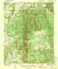
1943 Map of Cuba
USGS Topo · Published 1943About this map
Cuba serves as the focal point of this northern New Mexico landscape, situated at the edge of the Santa Fe National Forest and the Jicarilla Apache Indian Reservation. The map details a high-altitude ranching and subsistence farming environment, marked by isolated outposts like the Old Mestas Ranch and V R Ranch. The presence of numerous small rural schools, including Rio Puerco Sch, Vallecito Sch, and Capulin Sch, suggests a series of self-sufficient mountain communities connected by drainages like the Rito Puerco and Rio Gallina. High peaks such as San Pedro Reaks and Nacimiento Peak dominate the topography, while landmarks like the San Pedro Cabin and the Conference Grounds indicate a region used for both seasonal grazing and organized recreation during the early 1940s.
Find a feature on this map
60 named features on this map. Tap any name to fly to it.
Don’t see what you’re looking for? This feature index may not catch every label — zoom into the map to look around manually.
Map Details
Editions of this 1943 Cuba Map
2 editions found

Other maps of this area

1883 · Mt. Taylor
USGS Topo · 1:250,000

1886 · Mt. Taylor
USGS Topo · 1:250,000

1889 · Largo
USGS Topo · 1:250,000

1890 · Jemes
USGS Topo · 1:125,000

1892 · Jemes
USGS Topo · 1:125,000

1892 · Mt. Taylor
USGS Topo · 1:250,000

1895 · Largo
USGS Topo · 1:250,000

1899 · Mt. Taylor
USGS Topo · 1:250,000

1909 · Gallina
USGS Topo · 1:125,000

1937 · Jemez Springs
USGS Topo · 1:48,000