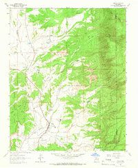
1963 Map of Cuba
USGS Topo · Published 1966About this map
Cuba serves as the focal point of this 1963 survey, situated where the Rio Puerco and Rito Leche converge. The settlement pattern reflects the mid-century development of Sandoval County, with the Cuba Ranger Station and a local High School indicating its role as a regional administrative and social hub. To the north, the small community of La Jara is anchored by the Santos Niños Church and La Jara School, illustrating the dispersed residential character typical of the high desert landscape.
Find a feature on this map
33 named features on this map. Tap any name to fly to it.
Don’t see what you’re looking for? This feature index may not catch every label — zoom into the map to look around manually.
Map Details
Editions of this 1963 Cuba Map
3 editions found
Other maps of this area

1883 · Mt. Taylor
USGS Topo · 1:250,000

1886 · Mt. Taylor
USGS Topo · 1:250,000

1889 · Largo
USGS Topo · 1:250,000

1890 · Jemes
USGS Topo · 1:125,000

1892 · Jemes
USGS Topo · 1:125,000

1892 · Mt. Taylor
USGS Topo · 1:250,000

1895 · Largo
USGS Topo · 1:250,000

1899 · Mt. Taylor
USGS Topo · 1:250,000

1909 · Gallina
USGS Topo · 1:125,000

1939 · La Ventana
USGS Topo · 1:62,500