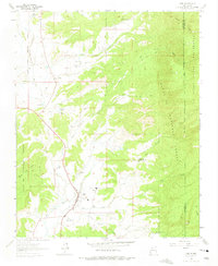
1963 Map of Cuba
USGS Topo · Published 1975About this map
The high mountain community of Cuba sits at the base of the Santa Fe National Forest, serving as a central hub for ranching and forest service operations in the early 1960s. The landscape is defined by the towering Mesa de Cuba to the west and the expansive San Pedro Parks Wilderness to the east, with numerous drainages like the Rito de los Puerco and Arroyo San Jose carving through the terrain. In the northern reaches, the settlements of Upper La Jara and La Jara are clearly marked, featuring local landmarks such as the Santos Niños Ch and La Jara Sch. The map also captures the Jicarilla Apache Indian Reservation Boundary along the northwestern edge, illustrating the complex intersection of federal, tribal, and private lands including the Circle A Ranch. Community life is reflected in the Rodeo Ground and the Cuba Ranger Sta positioned near the town center.
Find a feature on this map
40 named features on this map. Tap any name to fly to it.
Don’t see what you’re looking for? This feature index may not catch every label — zoom into the map to look around manually.
Map Details
Editions of this 1963 Cuba Map
3 editions found
Other maps of this area

1883 · Mt. Taylor
USGS Topo · 1:250,000

1886 · Mt. Taylor
USGS Topo · 1:250,000

1889 · Largo
USGS Topo · 1:250,000

1890 · Jemes
USGS Topo · 1:125,000

1892 · Jemes
USGS Topo · 1:125,000

1892 · Mt. Taylor
USGS Topo · 1:250,000

1895 · Largo
USGS Topo · 1:250,000

1899 · Mt. Taylor
USGS Topo · 1:250,000

1909 · Gallina
USGS Topo · 1:125,000

1939 · La Ventana
USGS Topo · 1:62,500