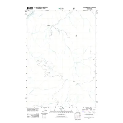
2011 Map of Cuddy Mountain
USGS Topo · Published 2011About this map
Wildhorse stands as a lonely settlement marker amidst a network of high-elevation drainages and ridges on the Idaho-Oregon border. The landscape is defined by the steep descent of the Wildhorse River and numerous tributaries like No Business Creek and Starveout Creek as they flow toward the Oxbow Reservoir on the Snake River. The proximity of Wildhorse Falls and the prominent peak of Cuddy Mountain suggests a geography of significant vertical relief, where travel is dictated by the winding paths of the Starveout Rd. Local history and genealogy interest is found in these remote place names and family-named water bodies such as Willy May Creek and Edna May Creek. This survey captures the region as it existed in 2011, detailing the intricate system of canyons and basins including Lost Basin before modern changes altered the accessibility of these high-country corridors.
Find a feature on this map
24 named features on this map. Tap any name to fly to it.
Don’t see what you’re looking for? This feature index may not catch every label — zoom into the map to look around manually.
Map Details
Editions of this 2011 Cuddy Mountain Map
This is the sole edition of this map. No revisions or reprints were ever made.
Other maps of this area

1955 · Baker
USGS Topo · 1:250,000

1957 · Cambridge
USGS Topo · 1:62,500

1957 · Copperfield
USGS Topo · 1:62,500

1957 · Hornet
USGS Topo · 1:62,500

1957 · Sturgill Peak
USGS Topo · 1:62,500

1959 · Baker
USGS Topo · 1:250,000

1980 · McCall
USGS Topo · 1:100,000
1986 · Crooked River Point
USGS Topo · 1:24,000
1986 · Rocky Comfort Flat
USGS Topo · 1:24,000
1986 · Rush Peak
USGS Topo · 1:24,000