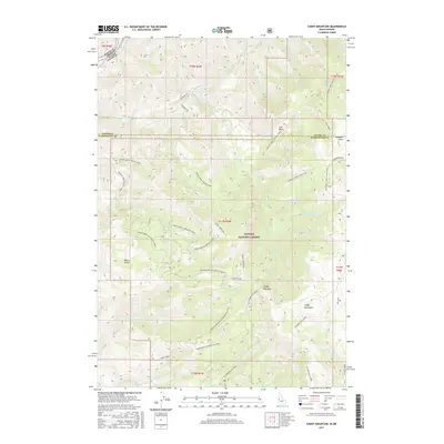
2017 Map of Cuddy Mountain
USGS Topo · Published 2017About this map
Cuddy Mountain and its surrounding peaks dominate this 2017 survey of the border region between Oregon and Idaho. The landscape is defined by the steep drainage systems of the Wildhorse River and its tributaries, including No Business Cr and Dukes Creek. The map documents a complex network of forest access routes like the Dukes Creek-Starveout Creek road and the Natl Forest Develop Road 234 Rd, reflecting the management and recreational infrastructure within the Payette National Forest. This high-altitude terrain is marked by distinct geographical features such as Board Gulch and Lost Basin. Genealogists and local historians may find interest in named locations like Summers Point and the Summers Grave-Lost Basin trail, which point to the early settlers and pioneers who navigated these remote canyons and ridges long before modern surveying.
Find a feature on this map
50 named features on this map. Tap any name to fly to it.
Don’t see what you’re looking for? This feature index may not catch every label — zoom into the map to look around manually.
Map Details
Editions of this 2017 Cuddy Mountain Map
This is the sole edition of this map. No revisions or reprints were ever made.
Other maps of this area

1955 · Baker
USGS Topo · 1:250,000

1957 · Cambridge
USGS Topo · 1:62,500

1957 · Copperfield
USGS Topo · 1:62,500

1957 · Hornet
USGS Topo · 1:62,500

1957 · Sturgill Peak
USGS Topo · 1:62,500

1959 · Baker
USGS Topo · 1:250,000

1980 · McCall
USGS Topo · 1:100,000
1986 · Crooked River Point
USGS Topo · 1:24,000
1986 · Rocky Comfort Flat
USGS Topo · 1:24,000
1986 · Rush Peak
USGS Topo · 1:24,000