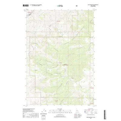
2020 Map of Cuddy Mountain
USGS Topo · Published 2020About this map
Payette National Forest dominates this high-elevation landscape along the border of Oregon and Idaho, where the Wildhorse River and Crooked River carve through steep drainages. The area is defined by massive ridges and remote basins, including the curiously named Summers Grave-Lost Basin and the prominent Cuddy Mountain. Transport through this difficult terrain is limited to forest service routes like Wildhorse Road and Starveout Road, which serve as the primary access points for the region's wilderness. The presence of Wildhorse Falls and numerous named creeks such as No Business Creek and Cracker Jack Creek illustrate a complex watershed system. For the researcher, the map preserves specific local landmarks like Summers Point and Board Gulch, offering a precise record of how these timberlands and high meadows were managed and named in the early 21st century.
Find a feature on this map
49 named features on this map. Tap any name to fly to it.
Don’t see what you’re looking for? This feature index may not catch every label — zoom into the map to look around manually.
Map Details
Editions of this 2020 Cuddy Mountain Map
This is the sole edition of this map. No revisions or reprints were ever made.
Other maps of this area

1955 · Baker
USGS Topo · 1:250,000

1957 · Cambridge
USGS Topo · 1:62,500

1957 · Copperfield
USGS Topo · 1:62,500

1957 · Hornet
USGS Topo · 1:62,500

1957 · Sturgill Peak
USGS Topo · 1:62,500

1959 · Baker
USGS Topo · 1:250,000

1980 · McCall
USGS Topo · 1:100,000
1986 · Crooked River Point
USGS Topo · 1:24,000
1986 · Rocky Comfort Flat
USGS Topo · 1:24,000
1986 · Rush Peak
USGS Topo · 1:24,000