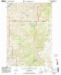
2004 Map of Cuddy Mountain
USGS Topo · Published 2007About this map
The Cuddy Mountains dominate this high-elevation Idaho landscape, where the Payette National Forest straddles the boundary between Adams and Washington counties. This 2004 revision reveals an area defined by steep drainage basins and significant mineral exploration. Numerous labels for Prospect, Prospects, and Adits are scattered across the southern slopes, particularly around the headwaters of Sturgill Creek and Business Creek, pointing to a history of geological survey and mining activity within the forest.
Find a feature on this map
33 named features on this map. Tap any name to fly to it.
Don’t see what you’re looking for? This feature index may not catch every label — zoom into the map to look around manually.
Map Details
Editions of this 2004 Cuddy Mountain Map
This is the sole edition of this map. No revisions or reprints were ever made.
Other maps of this area

1955 · Baker
USGS Topo · 1:250,000

1957 · Cambridge
USGS Topo · 1:62,500

1957 · Copperfield
USGS Topo · 1:62,500

1957 · Hornet
USGS Topo · 1:62,500

1957 · Sturgill Peak
USGS Topo · 1:62,500

1959 · Baker
USGS Topo · 1:250,000

1980 · McCall
USGS Topo · 1:100,000
1986 · Crooked River Point
USGS Topo · 1:24,000
1986 · Rocky Comfort Flat
USGS Topo · 1:24,000
1986 · Rush Peak
USGS Topo · 1:24,000