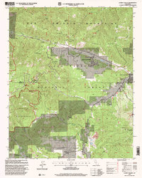
1995 Map of Cuddy Valley
USGS Topo · Published 2000About this map
The Andreas Rift Zone cuts a distinct northwest-to-southeast path across the landscape, shaping the valley floor where modern mountain communities developed by the mid-1990s. This survey of the San Emigdio Mountains shows the residential growth of Pine Mountain Club and Pinon Pines Estates alongside older recreational sites like the San Emigdio Girl Scout Camp. The transition from the rugged Chumash Wilderness in the west to the open flats of Cuddy Valley highlights the complex topography of the region. Local history is evidenced by the Stauffer (Site) in Lockwood Valley, a reminder of earlier borax mining and settlement patterns. Further east near the Frazier Mountain Road, the map documents several active or historical mineral interests, including the Good Luck Mine, Chalker Mine, and the Maule Mines, showing the continued presence of mining prospects in the Ventura and Kern county backcountry.
Find a feature on this map
50 named features on this map. Tap any name to fly to it.
Don’t see what you’re looking for? This feature index may not catch every label — zoom into the map to look around manually.
Map Details
Editions of this 1995 Cuddy Valley Map
This is the sole edition of this map. No revisions or reprints were ever made.
Other maps of this area

1903 · Mt. Pinos
USGS Topo · 1:125,000

1903 · Tejon
USGS Topo · 1:125,000

1942 · Eagle Rest Peak
USGS Topo · 1:24,000

1942 · Tecuya Creek
USGS Topo · 1:24,000

1942 · Frazier Mountain
USGS Topo · 1:24,000

1943 · San Guillermo
USGS Topo · 1:24,000

1943 · Sawmill Mountain
USGS Topo · 1:24,000

1943 · Cuddy Valley
USGS Topo · 1:24,000

1943 · Lockwood Valley
USGS Topo · 1:24,000
1944 · San Guillermo
USGS Topo · 1:31,680