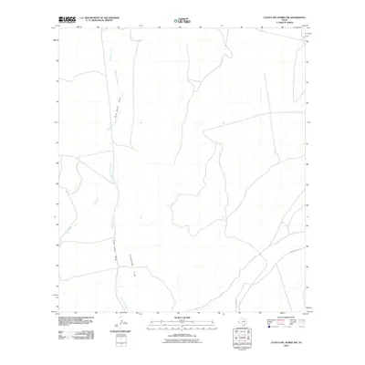
2010 Map of Cuesta Del Burro NW
USGS Topo · Published 2010About this map
Cleveland Flat dominates the central-southern reaches of this Presidio County landscape, characterized by a sparse drainage network and vast open terrain typical of the high Trans-Pecos. The geography is defined by seasonal watercourses, with Wild Horse Creek and Wild Horse Draw winding through the northern and western sections of the map. These ephemeral channels, along with Cat Creek, represent the primary topographic relief in an area primarily used for ranching and cattle grazing. Human presence is concentrated along the path of Ranch Rd 2810, which provides the single arterial connection through this portion of the Texas interior. The 2010 imagery provided by the U.S. Geological Survey reflects a landscape that remained largely undeveloped and pastoral into the twenty-first century.
Find a feature on this map
5 named features on this map. Tap any name to fly to it.
Don’t see what you’re looking for? This feature index may not catch every label — zoom into the map to look around manually.
Map Details
Editions of this 2010 Cuesta Del Burro NW Map
This is the sole edition of this map. No revisions or reprints were ever made.
Other maps of this area

1895 · Marfa
USGS Topo · 1:125,000

1896 · San Carlos
USGS Topo · 1:125,000

1959 · Marfa
USGS Topo · 1:250,000

1965 · Marfa
USGS Topo · 1:250,000
1978 · Capote Peak
USGS Topo · 1:24,000

1979 · Ruidosa Hot Springs
USGS Topo · 1:24,000

1979 · Capote Falls
USGS Topo · 1:24,000

1983 · Cuesta Del Burro East
USGS Topo · 1:24,000
1983 · Cuesta Del Burro NW
USGS Topo · 1:24,000
1983 · Cuesta Del Burro West
USGS Topo · 1:24,000