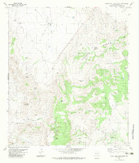
1983 Map of Cuesta Del Burro West
USGS Topo · Published 1983About this map
Cleveland Flat and the dramatic ridgelines of the Cuesta Del Burro dominate this high-desert region of Presidio County. The landscape is defined by the vital necessity of water management, evidenced by the numerous named stock tanks and windmills that supported the local ranching economy in the late twentieth century. Petan Ranch stands as a primary point of habitation in a terrain marked by sharp topographical features like Needle Peak and Cathedral Peak. Below these summits, Pinto Canyon and Wild Horse Draw cut through the arid flats, while a network of primitive infrastructure, including several Jeep Trails and a remote Landing Strip, provided essential access to these isolated outposts. Several mines and prospects suggest a history of mineral exploration tucked among the slopes of Love Mesa and the surrounding draws.
Find a feature on this map
28 named features on this map. Tap any name to fly to it.
Don’t see what you’re looking for? This feature index may not catch every label — zoom into the map to look around manually.
Map Details
Editions of this 1983 Cuesta Del Burro West Map
This is the sole edition of this map. No revisions or reprints were ever made.
Other maps of this area

1895 · Marfa
USGS Topo · 1:125,000

1896 · Ruidosa
USGS Topo · 1:125,000

1896 · San Carlos
USGS Topo · 1:125,000

1896 · Shafter
USGS Topo · 1:125,000

1959 · Presidio
USGS Topo · 1:250,000

1959 · Marfa
USGS Topo · 1:250,000

1965 · Presidio
USGS Topo · 1:250,000

1965 · Marfa
USGS Topo · 1:250,000

1978 · Sierra Parda
USGS Topo · 1:24,000

1979 · Ruidosa Hot Springs
USGS Topo · 1:24,000