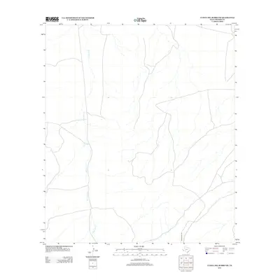
2012 Map of Cuesta Del Burro NW
USGS Topo · Published 2012About this map
Pinto Canyon Rd winds through the high desert terrain of Presidio County, serving as the primary corridor in this sparse West Texas landscape. The drainage network is defined by the intermittent flows of Wild Horse Cr and its tributary, Cat Cr, which carve a path through the Cuesta Del Burro foothills. This 2012 survey illustrates the remote nature of the Big Bend region, where vast stretches of open land are marked only by occasional unimproved roads and the natural contours of the arroyos. The map is a vital record for understanding the modern connectivity and hydrological patterns of this high-elevation plateau before any further development or environmental shifts occur in the Chihuahuan Desert.
Find a feature on this map
3 named features on this map. Tap any name to fly to it.
Don’t see what you’re looking for? This feature index may not catch every label — zoom into the map to look around manually.
Map Details
Editions of this 2012 Cuesta Del Burro NW Map
This is the sole edition of this map. No revisions or reprints were ever made.
Other maps of this area

1895 · Marfa
USGS Topo · 1:125,000

1896 · San Carlos
USGS Topo · 1:125,000

1959 · Marfa
USGS Topo · 1:250,000

1965 · Marfa
USGS Topo · 1:250,000
1978 · Capote Peak
USGS Topo · 1:24,000

1979 · Ruidosa Hot Springs
USGS Topo · 1:24,000

1979 · Capote Falls
USGS Topo · 1:24,000

1983 · Cuesta Del Burro East
USGS Topo · 1:24,000
1983 · Cuesta Del Burro NW
USGS Topo · 1:24,000
1983 · Cuesta Del Burro West
USGS Topo · 1:24,000