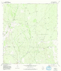
1972 Map of Cuevitas
USGS Topo · Published 1993About this map
Cuevitas and San Roman anchor this arid landscape along the border of Jim Hogg and Starr counties during the early 1970s. The terrain is defined by a sophisticated network of water management, essential for ranching and survival in this part of South Texas. Dozens of named windmills, such as Agua Buena Windmill, Filipino Windmill, and Tequileras Windmill, are scattered across the quadrangle, signaling the locations of vital groundwater sources.
Find a feature on this map
36 named features on this map. Tap any name to fly to it.
Don’t see what you’re looking for? This feature index may not catch every label — zoom into the map to look around manually.
Map Details
Editions of this 1972 Cuevitas Map
2 editions found
Other maps of this area

1938 · El Sauz
USGS Topo · 1:62,500

1938 · Agua Nueva
USGS Topo · 1:62,500

1938 · Sal Colorada
USGS Topo · 1:62,500

1938 · Cuevitas
USGS Topo · 1:62,500

1949 · Mc Allen
USGS Topo · 1:250,000

1954 · McAllen
USGS Topo · 1:250,000

1957 · Mc Allen
USGS Topo · 1:250,000

1962 · McAllen
USGS Topo · 1:250,000

1972 · Cuevitas
USGS Topo · 1:24,000
1972 · Guerra
USGS Topo · 1:24,000