
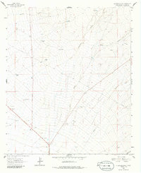
1963 Map of Culberson Ranch
USGS Topo · Published 1965About this map
Culberson Ranch and Reynolds Ranch anchor this arid New Mexico landscape, illustrating the importance of water infrastructure in the high desert of the 1960s. The map reveals a network of essential water sources, from windmills like Ballard Windmill and Davis Windmill to specialized stock tanks such as Aikens Tank, Garland Tank, and Still Tank. These features were vital for cattle operations in a region carved by seasonal drainages like Hoodoo Canyon and Thompson Canyon.
Find a feature on this map
23 named features on this map. Tap any name to fly to it.
Don’t see what you’re looking for? This feature index may not catch every label — zoom into the map to look around manually.
Map Details
Editions of this 1963 Culberson Ranch Map
2 editions found
Other maps of this area

1954 · Silver City
USGS Topo · 1:250,000

1958 · Silver City
USGS Topo · 1:250,000

1959 · Redrock
USGS Topo · 1:62,500

1959 · Canador Peak
USGS Topo · 1:62,500

1962 · Silver City
USGS Topo · 1:250,000

1962 · Lisbon
USGS Topo · 1:24,000

1963 · Lordsburg
USGS Topo · 1:24,000

1963 · Gold Hill
USGS Topo · 1:24,000

1964 · Gary
USGS Topo · 1:24,000
1964 · Ninemile Hill
USGS Topo · 1:24,000