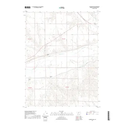
2017 Map of Culbertson NW
USGS Topo · Published 2017About this map
Massacre Canyon and the wide valley of the Republican River define this corner of Hitchcock County, where the topography of southwestern Nebraska meets significant historical memory. The canyon name reflects a localized geography shaped by steep breaks and deep drainages like Thompson Canyon and Big Canyon. The landscape reveals an extensive 20th-century water management system, tracing the courses of the Riverside Canal and the Upper Meeker Canal as they navigate the contours above the river bottom. To the northeast, Frenchman Creek joins the larger drainage system, while the path of Old Hwy 34 suggests the earlier transportation corridor that preceded modern local roads like N River Dr and Co Rd 367.
Find a feature on this map
25 named features on this map. Tap any name to fly to it.
Don’t see what you’re looking for? This feature index may not catch every label — zoom into the map to look around manually.
Map Details
Editions of this 2017 Culbertson NW Map
This is the sole edition of this map. No revisions or reprints were ever made.
Other maps of this area

1954 · McCook
USGS Topo · 1:250,000

1957 · McCook
USGS Topo · 1:250,000

1958 · McCook
USGS Topo · 1:250,000

1962 · Trenton
USGS Topo · 1:24,000

1962 · Culbertson NW
USGS Topo · 1:24,000

1962 · Culbertson SW
USGS Topo · 1:24,000
1962 · Trenton SE
USGS Topo · 1:24,000
1970 · Culbertson
USGS Topo · 1:24,000

1970 · Burger Canyon SE
USGS Topo · 1:24,000
1970 · Culbertson SE
USGS Topo · 1:24,000