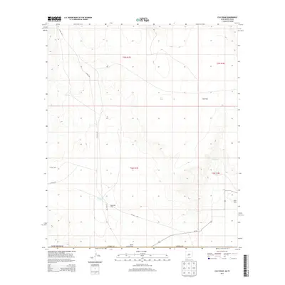
2013 Map of Culp Draw
USGS Topo · Published 2013About this map
Fourmile Draw and Culp Draw define the drainage patterns of this high-altitude landscape in Otero County during the early 21st century. The arid environment is marked by essential water catchment points for ranching or wildlife, such as Fourmile Tank, Jim Tank, and the isolated Lost Pond. The infrastructure of the area is primarily composed of a network of county roads, including Co Road G001 and Co Road G003, alongside the state-maintained Nm-506 crossing the southern portion. Surveyed sections and township lines reflect the systematic land management of this remote borderland region, where terrain features like Club Draw and North Draw provide the only major relief in an otherwise expansive and open territory.
Find a feature on this map
19 named features on this map. Tap any name to fly to it.
Don’t see what you’re looking for? This feature index may not catch every label — zoom into the map to look around manually.
Map Details
Editions of this 2013 Culp Draw Map
This is the sole edition of this map. No revisions or reprints were ever made.
Other maps of this area

1951 · Dell City
USGS Topo · 1:62,500

1954 · Carlsbad
USGS Topo · 1:250,000

1954 · Van Horn
USGS Topo · 1:250,000

1955 · Cerro Diablo
USGS Topo · 1:62,500

1958 · Van Horn
USGS Topo · 1:250,000

1958 · Carlsbad
USGS Topo · 1:250,000

1969 · Lewis Canyon
USGS Topo · 1:24,000
1969 · Sheep Draw
USGS Topo · 1:24,000
1969 · Cienega School
USGS Topo · 1:24,000
1969 · Culp Draw
USGS Topo · 1:24,000