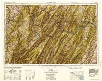
1952 Map of Cumberland
USGS Topo · Published 1952About this map
Cumberland serves as the focal point of this mid-century regional survey, situated at the dramatic intersection of the Potomac River and the complex ridgelines of the Allegheny Mountains. The map illustrates a landscape defined by sharp linear ridges and narrow valleys, where the North Branch Potomac River and the South Branch Potomac River carve intricate paths through the terrain. Civil infrastructure reflects the difficult geography, with settlements like Frostburg, Oakland, and Keyser positioned along vital transit corridors that overcome the natural barriers of Savage Mountain and Sideling Hill.
Find a feature on this map
87 named features on this map. Tap any name to fly to it.
Don’t see what you’re looking for? This feature index may not catch every label — zoom into the map to look around manually.
Map Details
Editions of this 1952 Cumberland Map
This is the sole edition of this map. No revisions or reprints were ever made.
Other maps of this area

1884 · Harpers Ferry
USGS Topo · 1:125,000

1886 · St. George
USGS Topo · 1:125,000

1889 · Beverly
USGS Topo · 1:125,000

1891 · Harpers Ferry
USGS Topo · 1:125,000

1891 · St. George
USGS Topo · 1:125,000

1891 · Romney
USGS Topo · 1:125,000

1892 · Beverly
USGS Topo · 1:125,000

1892 · Franklin
USGS Topo · 1:125,000

1892 · Woodstock
USGS Topo · 1:125,000

1893 · Buckhannon
USGS Topo · 1:125,000