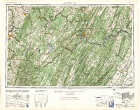
1957 Map of Cumberland
USGS Topo · Published 1957About this map
Cumberland sits at a critical junction of the Potomac River and Wills Creek, serving as a mountain gateway where the Baltimore and Ohio RR and Western Maryland Ry intersect. This mid-century survey illustrates the complex ridges and valleys of the Appalachian highlands, dominated by the Allegheny Front and the high elevations of Negro Mountain. The landscape reveals a pattern of industrial and recreational development, from the engineering of the Stony River Dam and Tygart River Reservoir to the growing presence of Deep Creek Lake in Garrett County.
Find a feature on this map
171 named features on this map. Tap any name to fly to it.
Don’t see what you’re looking for? This feature index may not catch every label — zoom into the map to look around manually.
Map Details
Editions of this 1957 Cumberland Map
This is the sole edition of this map. No revisions or reprints were ever made.
Other maps of this area

1884 · Harpers Ferry
USGS Topo · 1:125,000

1886 · St. George
USGS Topo · 1:125,000

1889 · Beverly
USGS Topo · 1:125,000

1891 · Harpers Ferry
USGS Topo · 1:125,000

1891 · St. George
USGS Topo · 1:125,000

1891 · Romney
USGS Topo · 1:125,000

1892 · Beverly
USGS Topo · 1:125,000

1892 · Franklin
USGS Topo · 1:125,000

1892 · Woodstock
USGS Topo · 1:125,000

1893 · Buckhannon
USGS Topo · 1:125,000