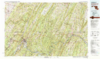
1981 Map of Cumberland
USGS Topo · Published 1982About this map
Cumberland serves as the focal point of this Appalachian landscape, where the North Branch Potomac River and Wills Creek converge at the historic gap in Wills Mountain. By the early 1980s, the region's complex industrial and transportation legacy is clearly visible through the intertwined routes of the B & O RR, the Western Maryland RR, and the C & O Canal. The map captures the dense cluster of mining and industrial towns such as Frostburg, Eckhart Mines, and Mount Savage, which are linked by Maryland 36 and U.S. 40.
Find a feature on this map
226 named features on this map. Tap any name to fly to it.
Don’t see what you’re looking for? This feature index may not catch every label — zoom into the map to look around manually.
Map Details
Editions of this 1981 Cumberland Map
2 editions found
Other maps of this area

1884 · Harpers Ferry
USGS Topo · 1:125,000

1891 · Harpers Ferry
USGS Topo · 1:125,000

1891 · Romney
USGS Topo · 1:125,000

1893 · Harpers Ferry
USGS Topo · 1:125,000

1894 · Winchester
USGS Topo · 1:125,000

1895 · Piedmont
USGS Topo · 1:125,000

1898 · Frostburg
USGS Topo · 1:62,500

1898 · Paw Paw
USGS Topo · 1:62,500

1899 · Flintstone
USGS Topo · 1:62,500

1899 · Grantsville
USGS Topo · 1:62,500