
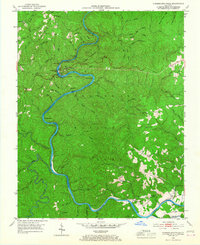
1952 Map of Cumberland Falls
USGS Topo · Published 1954About this map
Cumberland Falls State Park centers this 1950s survey, capturing the dramatic bend in the river where the namesake falls drop before flowing northwest past Blue Bend. The surrounding landscape of the Cumberland National Forest is deeply incised by numerous tributaries, including Dog Slaughter Br and Bunches Creek, reflecting the difficult terrain that kept this portion of the Cumberland Plateau sparsely populated.
Find a feature on this map
104 named features on this map. Tap any name to fly to it.
Don’t see what you’re looking for? This feature index may not catch every label — zoom into the map to look around manually.
Map Details
Editions of this 1952 Cumberland Falls Map
2 editions found
Other maps of this area

1890 · Williamsburg
USGS Topo · 1:125,000

1894 · Williamsburg
USGS Topo · 1:125,000

1952 · Wofford
USGS Topo · 1:24,000

1952 · Hail
USGS Topo · 1:24,000

1952 · Vox
USGS Topo · 1:24,000

1952 · Hollyhill
USGS Topo · 1:24,000

1952 · Wiborg
USGS Topo · 1:24,000

1952 · Williamsburg
USGS Topo · 1:24,000

1952 · Whitley City
USGS Topo · 1:24,000
1952 · Sawyer
USGS Topo · 1:24,000