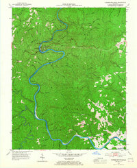
1952 Map of Cumberland Falls
USGS Topo · Published 1967About this map
Cumberland Falls State Park and the surrounding reaches of the Cumberland National Forest define this 1950s landscape along the border of McCreary and Whitley counties. The Cumberland River carves a deep path through the center of the sheet, featuring notable river landmarks like McKee Bend, Amos Falls, and a Ferry crossing. The settlement of Honeybee sits on the western heights above Eagle Creek, while the ridges are dotted with essential community hubs including Rock Branch Sch, Sand Hill Sch, and Oak Ridge Ch. Two distinct fire lookouts, the Pinnacle Lookout Tower and New Liberty Lookout Tower, offer a glimpse into the forest management of the era. This survey captures a time when small rural schoolhouses and churches still served as the primary social anchors for families living along the remote ridges and hollows like Polly Hollow.
Find a feature on this map
74 named features on this map. Tap any name to fly to it.
Don’t see what you’re looking for? This feature index may not catch every label — zoom into the map to look around manually.
Map Details
Editions of this 1952 Cumberland Falls Map
2 editions found
Other maps of this area

1890 · Williamsburg
USGS Topo · 1:125,000

1894 · Williamsburg
USGS Topo · 1:125,000

1952 · Wofford
USGS Topo · 1:24,000

1952 · Hail
USGS Topo · 1:24,000

1952 · Vox
USGS Topo · 1:24,000

1952 · Hollyhill
USGS Topo · 1:24,000

1952 · Wiborg
USGS Topo · 1:24,000

1952 · Cumberland Falls
USGS Topo · 1:24,000

1952 · Williamsburg
USGS Topo · 1:24,000

1952 · Whitley City
USGS Topo · 1:24,000