1935 Map of Cumberland Gap
USGS Topo · Published 1935About this map
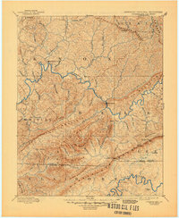
The Cumberland Gap serves as the focal point of this 1935 survey, marking the historic mountain pass where Tennessee, Kentucky, and Virginia meet. The landscape is defined by the massive ridge of Cumberland Mountain and the deep incision of the Powell River, which winds through Kings Bend toward the newly formed Norris Reservoir. The map documents a critical period of infrastructure development by the Tennessee Valley Authority, showing the reservoir's reach near Underwood School and the Powell River Bridge. Local industry and social life are anchored by landmarks like Vancel Mill, the Grace Nettleton Home, and the campus of Lincoln Memorial University. Transportation networks including the Southern Railway and the Wilderness Trail underscore the gap's enduring role as a primary corridor for movement through the Appalachians.
Find a feature on this map
64 named features on this map. Tap any name to fly to it.
Don’t see what you’re looking for? This feature index may not catch every label — zoom into the map to look around manually.
Map Details
Editions of this 1935 Cumberland Gap Map
This is the sole edition of this map. No revisions or reprints were ever made.
Historical Maps of Middlesboro Through Time
4 maps found