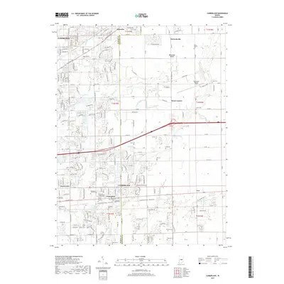
2019 Map of Cumberland
USGS Topo · Published 2019About this map
Cumberland sits as a central hub along the border of Marion and Hancock Counties, where suburban expansion meets the organized grid of Indiana's rural farmland. This 2019 survey captures the transition between the urban reach of Lawrence and Warren Hills and the outlying communities of Mount Comfort and Gem. The landscape is heavily defined by its complex drainage network, including Buck Creek, Jay Ditch, and O'Brian Ditch, which underscore the region's agricultural foundations. For researchers, the sheer density of small family and community burial sites is remarkable, with over twenty distinct locations such as Washington Park East Cemetery, the German Church Road Cemetery, and the dual Cumberland Penny sites. The northeast corner is anchored by the Indianapolis Regional Airport, formerly known as Mount Comfort Airport, serving as a modern landmark amidst older settlements like Oaklandon and McCordsville.
Find a feature on this map
110 named features on this map. Tap any name to fly to it.
Don’t see what you’re looking for? This feature index may not catch every label — zoom into the map to look around manually.
Map Details
Editions of this 2019 Cumberland Map
This is the sole edition of this map. No revisions or reprints were ever made.
Other maps of this area

1948 · Indianapolis East
USGS Topo · 1:24,000

1948 · Beech Grove
USGS Topo · 1:24,000

1952 · Cumberland
USGS Topo · 1:24,000

1952 · Greenfield
USGS Topo · 1:24,000

1952 · Fountaintown
USGS Topo · 1:24,000

1952 · Fishers
USGS Topo · 1:24,000

1952 · Ingalls
USGS Topo · 1:24,000

1952 · Mc Cordsville
USGS Topo · 1:24,000

1953 · Acton
USGS Topo · 1:24,000

1953 · Cincinnati
USGS Topo · 1:250,000